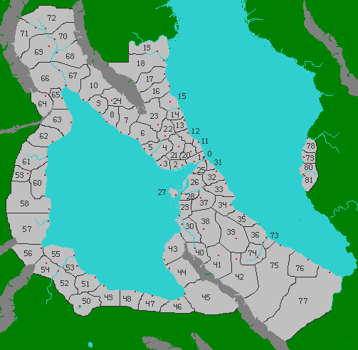
Zekresh Empire Province Map
Scale: this map is a little over 12,000 Talong (6,000 km) on each side.
Province names are listed by province number here.
Explanations of the maps:
On all maps:
Dark grey masses indicate mountain ranges.
Light blue indicates water and can be lakes, rivers or seas depending on size and shape.
On some maps that have not yet been revealed, dark blue indicates deeper ocean waters.
Light grey marks lands that are part of the Zekresh Empire.
Black lines mark the borders of provinces and nations.
Green indicates lands that are not under imperial control.
Green dots in the sea are islands that are not under imperial control. If they are near a coast controlled by the Empire, the islands are claimed by the Empire, but not under actual Imperial control.
Some mountain valleys are also green or partly green even though they are in the middle of the Empire. This is not a mistake. The green lands are not under imperial control. In the case of mountain valleys, this is generally because they are relatively inaccessible. After there is a player for every province, new players may take the part of leaders of independent enclaves in the green mountain valleys or islands or as the leaders of barbarian tribes beyond the imperial borders.
On the province map above:
On the map above, each province is identified with a number. Black lines mark province borders. Some province borders are not marked with black lines because an obvious natural obstacle forms the border such as a coastline, mountain range or river. Sometimes both sides of a river are part of the same province and in other cases, each side of the river is a separate province. The placement of the province numbers on the map makes clear which rivers are province boundaries. If there is only one number, it is one province, regardless of whether a river runs through it. If there is a number on each side of the river, it is two provinces. Provincial capitals are marked with small red squares. The Imperial Capital City of Zekran is shown as a small purple square with a boundary around it marking the territory associated with it that is not considered part of any province. The Imperial City of Zekran is located at the northeastern end of the straits connecting the Eastern Sea with the Western Sea.
Small red dots outside the Zekresh Empire are active volcanoes. They are often surrounded or partly surrounded with grey squares indicating mountainous terrain. There are no active volcanoes inside the empire.
The province names are posted here.
No comments:
Post a Comment